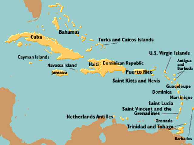
| Cuba in the Carribbean (20kb) | ||
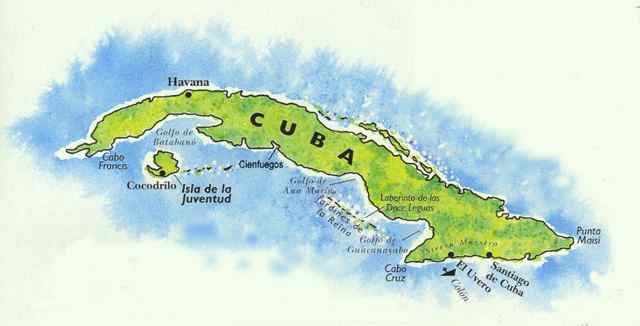
| Cuba Area Map (16kb) | ||
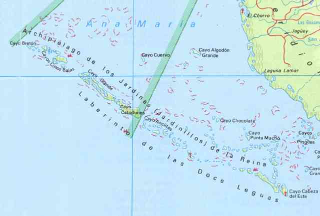
| La Jardines de la Reina - The Queen's Garden (18kb) |
Ocean Photos Cuba Maps & Dive Site Locations
| Cuba in the Carribbean (20kb) | ||
| Cuba Area Map (16kb) | ||
| La Jardines de la Reina - The Queen's Garden (18kb) |
"GROUPER
HOLE" Dive Site Description
![]()
 |
N21*
03.891 W79* 26.551 South of Cayo Breton |
Anchor in 60-70 foot of water. Dense flat coral reef with some sand fingers. Swim southwest in the direction of the fingers for more topography and the edge of the wall. The wall starts at 90-95 feet and drops fast to about 600 feet.
"SHARK
BIGHT" Dive Site Description
![]()
|
N21*
01.679 W79* 19.078 Southwest of Cayo Alcatracito |
This is the edge of a very dramatic and steep wall which begins at 80-90 feet. There are coral gardens with good relief behind it in 70 feet of water. The corals and sponges here are healthy, abundant and continue down the wall as far as you can see.
There are several very nice overhangs and pinnacles. The site has a pristine feel to it and is reminiscent of some of Grand Cayman's best north wall diving.
"FOUR
PILLARS" Snorkel Site Description
![]()
|
N21*
04.700 W79* 29.000 Southwest of Cayo Breton |
From this coordinate you can see four concrete pillars to the north. Approach carefully and drop anchor in 25 feet of water. From here you can snorkel towards the pillars in depths of 8-2 feet. A long past storm has piled monstrous pieces of stag horn corals in heaps that look like they were pushed together with a bulldozer.
Barracuda, reef fish and green morays are abundant and a toad fish was also seen.
Swim towards Cayo Breton and the reef opens enough to swim to the other side. This side is more sandy and better lit.
"CAYO
BLANCO" Snorkel Site Description
![]()
|
N21*
38.500 W79* 53.500 Cayo Blanco |
Approach the island from the northeast heading directly towards the building on the beach. Anchor 100 yards off shore and in 8 feet of water to the right of the building is the remains of a shipwreck.
The hull ribs are still above water and many juvenile fish school at the wreck.
In the sand and sea grass areas toad fish seem common. Anemones and conch are also abundant.
The beach building is a bar for tourists brought in by boat and the proprietors quite hospitable.
"CAYO
ALCATRACITO FRINGING REEF" Snorkle Site Description
![]()
|
N21*
02.400 W79* 19.700 Cayo Alactracito |
Anchor on the south side of the island inside the reef. The depth of the sound is 6-8 feet. There is a cut in the reef at N21* 02.400 W79* 19.700. Once inside bear east until about the center of the island. The bottom is mostly eel grass with a coral garden to the east with an abundance of lobster.
Snorkel directly to the left of the breaking portion of the reef. Here there are magnificent stands of very healthy Elkhorn Coral, schooling grunts, barracuda and other reef fish.
"GRAND
CANYONS" Dive Site Description
![]()
|
N20*
55.085 W79* 07.773 South of Cayo Grande |
This area is notable on the charts for unusual depth markings. It's located south of Cayo Grande between Punta Coseta Blanca and Punta Baya Meses.
A spectacular deep dive with a steeply dropping wall. The wall is at 80-100 feet and the area leading to it is strafed with deep canyons and ravines. There are many swim throughs and the terrain is very dramatic. There are plenty of large fish as well as schools of reef fish. A spectacular dive site!
"QUEEN'S
GATE" Dive Site Description
![]()
|
N21*
01.644 W79* 19.631 South of Cayo Casimba de Cinco Balas |
From what I've seen of the Garden of the Queen, the best diving begins in this area though the Garden actually begins at the Canal de Breton. This spot is due south of Cayo Casimba de Cinco Balas.
Anchorage is in between 70 and 90 feet, the wall begins to drop anywhere from 80-110 feet. There are large buttresses and ravines accounting for the depth variations. The large fish population is not quite as dense here as some of the other sites further east.
"PRITCHARD'S
DESIRE" Dive Site Description
![]()
|
N21*
04.479 W79* 28.350 Cayo Breton |
Chris wanted a dive near Cayo Breton that might be representative of the terrain and walls further down Queen's Garden. After several attempts we found it here. A steep wall starting at 90-100 feet. Ravines leading to the wall with buttresses of 10 feet or so. This region begins the good diving of "Jardines de la Reina".
"BLANCO
WALL" Dive Site Description
![]()
|
N21*
37.830 W79* 52.934 Southeast of Cayo Blanco |
This area, located about 1 mile southeast of the lighthouse on Cayo Blanco is somewhat unique from the walls and reefs further down Queen's Garden. The wall begins at only 50 feet and is every bit as dramatic as the deeper locations. The finger reefs leading to it are 15-25 feet high and steep as well. The coral is vibrant and healthy though the fish populations are reduced from ongoing fishing in the area.
"LADY
FINGERS" Dive Site Description
![]()
|
approx N21* 31.000 W79* 41.100 |
This area's characteristics are of delicate finger reefs about 2-3 feet high with sandy bottoms extending south. The fingers end to the south in about 45 feet of water and reach a height of 5-6 feet. Lobster can be found at the ends but seem to be much more prevalent in the coral gardens inside the fringing reefs of the Cayos.